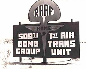
The Roswell International Air Center (RIAC) is located 5 kilometers to the south of the city of Roswell in full industrial heart of the southeast of the State. In the late 40's functioned there an important military air base known as Roswell Army Air Field, where were stationed B-29 airplanes belonging to the 509th Wing of Bombardment. In those times it was the first air squad of the world with nuclear weapons launch capacity.

In June 1949 the base was transfered to the Department of the Air Force being renamed as Walker Air Force Base (Walker AFB) and remaining active during all the decade of the 50's and part of the following decade.
A great change would occur in the following decade, when the place was elected for the installation of launch silos of Atlas and Titan intercontinental nuclear missiles capable to carry its mortal charges as far as the Soviet Union. The subterranean work construction begin in 1961 and was completed a year later. Nevertheless, in 1965, after the occurrence of various accidents and even explosions (non nuclear of course) in the installations that lodged the rockets, the air force decides to dismantle the system. Thus, the following year, is announced that the base will be closed on July First, 1967.
After that, the city of Roswell acquired the control of the terrain and began to utilize it for the development of an industrial park. On regard the aerial facilities, they started to be used for civil aviation activities, leading later to establish there the Roswell Municipal Airport.
Early balloon launches
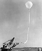
The activities with stratospheric balloons were carried out at RIAC starting in the middle of the decade of the 60's. The launches were performed by the Air Force under guidance of the Balloon Operations Division based on the nearby Holloman Air Force Base in Alamogordo. During that times, in full boom of the spatial development, were performed several flight test of reentry capsules, vehicles and probes that would be used in the atmosphere of other planets. To simulate the conditions of reentry that the real craft would suffer in its landing in other worlds, the test models were transported by balloon to the stratosphere and once there jettisoned in free fall. After an initial phase of free flight, the retrorockets were fired completing the maneuver and acquiring the velocity and attitude of flight to simulate an orbital entry.

Taking account of the security measures needed for this activity, all these landing test were intended to be carried out over the restricted space of the nearby White Sands Missile Range, located west of the city. Due to the fact that the range possesses a rectangular form oriented in South North sense, during those times of year in which the winds blew from the east, the balloons need to be launched from a place located east of the range.
One of the best places to conduct these operations was RIAC, because it was located right to the east of the Range and offered good space to allow the operation of big balloons with heavy payloads. Once in the air while the balloons were climbing to the desire test altitude they follow a westward path. At reaching float altitude, they already were flying over restricted air space at the range.
This kind of operations were performed in the framework of PEPP (Planetary Entry Parachute Program), Discovery and Viking programs among others. During part of the 80's decade other flights of similar flight pattern characteristics were performed, but intended to make diffrent experiments over the range. Among these is worth to mention ABLE I and II which involved the firing of lasers toward the ground with the purpose to measure atmospheric variables for later analisis. These test are the last known references of balloon launched at RIAC for many years.
Balloon activity today
Nowadays, along with the airport, the site lodges several businesses that are dedicated to the air industry, (repair and maintenance of aircraft), which in great number are stationed inside the complex. Also, diverse industries of manufacture are located there as fireworks, candies, plastics, buses, and even a unit of the National Guard.

Althought the last missions were carried out in the late 80's, a few scattered balloon missions were performed in the following decades but far from the numbers of early years. The last one -that took place in 2005- was a test flight of a stratospheric airship called HiSentinel.
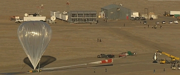
Nevertheless, in late 2011, was revealed that the Roswell International Air Center have been choosen as launch base for the RED BULL Stratos project, a fully private effort mainly funded by the worldwide energy drinking company, with the aim to beat the record of the highest jump established by Joe Kittinger back in 1960 in the framework of the EXCELSIOR program of the USAF.
Following the announcement, a fully equiped, state of the art control center was established in the airport, and several flight tests were performed duirng december 2011, as an anticipation of the full mission to be performed during the boreal summer. The project had his kick-off in March 2012 and was completed succesfully in October, when the austrian parachutist Felix Baumgartner performed a stratospheric jump from 128.000 feet and broke several records.
Last than two years after the completion of the Red Bull Stratos feat, another intitiative called STRATEX took place at RIAC, first performing some unmanned test balloon launches, in tight secrecy. The existence of the project was only revealed to the world on October 2014, when google's executive Alan Eustace, performed a free fall from 135.889 feet, beating the free fall jump record.
Also, the site was used to launch balloons for World View Enterprises, a Tucson based firm that is planning to develope near-space tourism using stratospheric balloons.
Balloons launched from Roswell Municipal Airport
| Date | Hour | Flight Duration | Experiment | Payload landing place or cause of the failure |
|---|---|---|---|---|
| 7/21/1981 | 7:57 local | ~ 4 h | BAMM II (Balloon Altitude Mosaic Measurements) | In White Sands Rocket Range, New Mexico, US |
Balloons launched from Roswell Industrial Air Center
| Date | Hour | Flight Duration | Experiment | Payload landing place or cause of the failure |
|---|---|---|---|---|
| 8/28/1966 | 11:04 MST | --- | PATHFINDER | --- No Data --- |
| 8/29/1966 | 21:55 mst | --- | PATHFINDER | --- No Data --- |
| 8/29/1966 | --- | PATHFINDER | --- No Data --- | |
| 8/30/1966 | 7:17 MST | 3 h 25 m | PEPP (Planetary Entry Parachute Program) #1 | In the White Sands Missile Range, in the center of the so called "50 mile area", New Mexico, US |
| 7/28/1967 | --- | PEPP (Planetary Entry Parachute Program) #2 | --- No Data --- | |
| 8/15/1967 | --- | PEPP (Planetary Entry Parachute Program) #3 | --- No Data --- | |
| 8/22/1967 | --- | PEPP (Planetary Entry Parachute Program) #4 | --- No Data --- | |
| 7/11/1972 | 14:35 utc | 3 h | VIKING PARACHUTE TEST - AV1 (Supersonic) | --- No Data --- |
| 7/26/1972 | 14:03 utc | 3 h | VIKING PARACHUTE TEST - AV2 (Transonic) | --- No Data --- |
| 8/13/1972 | 13:40 utc | 3 h | VIKING PARACHUTE TEST - AV4 (Supersonic) | --- No Data --- |
| 8/19/1972 | 17:45 utc | 5 h | VIKING PARACHUTE TEST - AV3 (Subsonic) | --- No Data --- |
| 7/9/1982 | --- | GALILEO PATHFINDER | --- No Data --- | |
| 7/17/1982 | ~ 5 h | GALILEO PROBE PARACHUTE TEST | Over White Sands Missile Range, New Mexico, US, USA | |
| 7/17/1983 | GALILEO PROBE PARACHUTE TEST | Over White Sands Missile Range, New Mexico, US, USA | ||
| 7/23/1983 | --- | GALILEO PATHFINDER | --- No Data --- | |
| 7/24/1983 | --- | GALILEO PATHFINDER | --- No Data --- | |
| 7/25/1983 | --- | GALILEO PROBE PARACHUTE TEST | Over White Sands Missile Range, New Mexico, US, USA | |
| 6/29/1984 | --- | BIMS (Balloon Borne Ion Mass Spectrometer) | --- No Data --- | |
| 7/5/1984 | 6:10 mdt | --- | SCRIBE (Stratospheric CRyogenic Interferometer Balloon Experiment) | --- No Data --- |
| 8/23/1984 | --- | ABLE I (Atmospheric Balloon Lidar Experiment) | Over White Sands Missile Range, New Mexico, US, USA | |
| 6/21/1985 | 1:55 mdt | 1 h | SCRIBE (Stratospheric CRyogenic Interferometer Balloon Experiment) | Balloon damaged at launch |
| 7/21/1986 | --- | SCRIBE 99 PATHFINDER | --- No Data --- | |
| 7/30/1986 | --- | SCRIBE 99 (Stratospheric Cryogenic Interferometer Balloon Experiment) | --- No Data --- | |
| 8/4/1986 | 7:30 local (13:30 utc) | 5 h 15 m | ALFAN I (Airborne Measurement of Low Frequency Atmospheric Noise) | Near Alamogordo, New Mexico, US |
| 8/10/1986 | 6:00 mst | --- | SCRIBE 99 (Stratospheric Cryogenic Interferometer Balloon Experiment) | --- No Data --- |
| 6/25/1987 | --- | SCRIBE 99 (Stratospheric Cryogenic Interferometer Balloon Experiment) | On the White Sands Missile Range, New Mexico, US | |
| 8/30/1987 | 20:21 MDT | 4 h 39 m | ABLE II (Atmospheric Balloon Lidar Experiment) | Gardner Peak, New Mexico, US |
| 7/28/1990 | 12:26 mdt | 4 h 40 m | PATHFINDER PROGRAM | --- No Data --- |
| 7/29/1990 | 9:09 mdt | 3 h 55 m | PATHFINDER PROGRAM | --- No Data --- |
| 7/30/1990 | 4:14 mdt | 5 h 25 m | PATHFINDER PROGRAM | --- No Data --- |
| 7/31/1990 | 23:58 mdt | 5 h 40 m | PATHFINDER PROGRAM | --- No Data --- |
| 8/2/1990 | 19:16 mdt | 4 h 25 m | PATHFINDER PROGRAM | --- No Data --- |
| 11/8/2005 | 13:39 | 5 h | HISENTINEL (Stratospheric Airship) | 103 miles E-SE of Roswell, New Mexico just across the state line in Texas. |
| 12/15/2011 | --- | RED BULL STRATOS - Unmanned test - POD | Balloon failure at launch | |
| 12/16/2011 | --- | RED BULL STRATOS - Unmanned test - POD | --- No Data --- | |
| 1/18/2012 | --- | RED BULL STRATOS - Unmanned test - POD | --- No Data --- | |
| 3/13/2012 | --- | RED BULL STRATOS I - (Baumgartner) | Balloon failure at launch | |
| 3/15/2012 | --- | RED BULL STRATOS I - (Baumgartner) | 20 miles E of Roswell, New Mexico, US | |
| 7/25/2012 | --- | RED BULL STRATOS II - (Baumgartner) | Near Roswell, New Mexico, US | |
| 10/9/2012 | --- | RED BULL STRATOS III - (Baumgartner) | Ground Abort. Balloon destroyed by a gust of wind during inflation | |
| 10/9/2012 | --- | RED BULL STRATOS III - Sonde | --- No Data --- | |
| 10/14/2012 | --- | RED BULL STRATOS III - (Baumgartner) | 37 miles E of Roswell, New Mexico, US | |
| 10/14/2012 | --- | RED BULL STRATOS III - Sonde | --- No Data --- | |
| 10/8/2013 | --- | STRATEX UNCREWED TEST | --- No Data --- | |
| 6/18/2014 | 5 h | TYCHO285 | --- No Data --- | |
| 7/3/2014 | --- | STRATEX UNCREWED TEST | --- No Data --- | |
| 10/4/2014 | --- | STRATEX #1 (Eustace) | --- No Data --- | |
| 10/15/2014 | --- | STRATEX #2 (Eustace) | In New Mexico, US | |
| 10/24/2014 | 7:00 mdt | 2 h 23 m | STRATEX #3 (Eustace) | 70 miles from Roswell, New Mexico, US |
| 7/11/2020 | 11:00 utc | 7 h 30 m | RAVEN AEROSTAR FLIGHT 0418 | SW of Denim, New Mexico, US |
| 7/11/2020 | 9:00 utc | 10 h | RAVEN AEROSTAR FLIGHT 0417 | SW of Hatch, New Mexico, US |
| 7/11/2020 | 10:00 utc | 2 h | RAVEN AEROSTAR FLIGHT 0420 | Last known position W of Roswell, New Mexico, US |
| 7/11/2020 | 5:00 utc | 13 h | RAVEN AEROSTAR FLIGHT 0419 | SW of Denim, New Mexico, US |
| 7/11/2020 | 6:00 utc | 13 h | RAVEN AEROSTAR FLIGHT 0421 | SW of Hatch, New Mexico, US |
| 7/11/2020 | 8:00 utc | 9 h | RAVEN AEROSTAR FLIGHT 0416 | W of Derry, New Mexico, US |
| 8/31/2020 | 14:33 utc | 31 h | THUNDERHEAD FLIGHT 0441 | Near Hatch, New Mexico, US |
| 8/31/2020 | 13:43 utc | 15 h | THUNDERHEAD FLIGHT 0440 | 36 km NW of Carrizozo, New Mexico, US |
| 8/31/2020 | 12:30 utc | 33 h | THUNDERHEAD FLIGHT 0439 | W of Garfield, New Mexico, US |
| 9/14/2020 | 18:00 utc | 4 d | THUNDERHEAD FLIGHT 0464 | 20 miles E of El Paso, Texas, US |
| 9/14/2020 | 17:00 utc | 2 d | THUNDERHEAD FLIGHT 0463 | Last known position over Cornudas Mountains, near the NM/TX border, US |
| 9/14/2020 | 16:00 utc | 2 d | THUNDERHEAD FLIGHT 0462 | 10 miles SW of Las Cruces, New Mexico, US |
| 9/15/2020 | 10:00 utc | 3 d | THUNDERHEAD FLIGHT 0459 | 15 miles SE of Lordsburg, New Mexico, US |
| 9/15/2020 | 11:00 utc | 2 d | THUNDERHEAD FLIGHT 0461 | In Culberson County, Texas, US |
| 5/19/2021 | 17:20 utc | 2 h 10 m | SCEYE- STRATOSPHERIC AIRSHIP | --- No Data --- |
| 6/14/2022 | 12:55 utc | 3 h 50 m | SCEYE- STRATOSPHERIC AIRSHIP | 40 km SW of Portales, New Mexico, US |
| 10/29/2022 | 16:40 utc | 4 h 30 m | SCEYE- STRATOSPHERIC AIRSHIP | SE of Meadow, Texas, US |
| 5/17/2023 | 12:15 utc | 2 h 30 m | SCEYE- STRATOSPHERIC AIRSHIP | 27 km E of Roswell, New Mexico, US |
| 7/1/2023 | 17:00 utc | 4 h | SCEYE- STRATOSPHERIC AIRSHIP | N of Lovington, New Mexico, US |
| 8/16/2023 | 15:30 utc | 3 h | SCEYE- STRATOSPHERIC AIRSHIP | 46 km W of Artesia, New Mexico, US |
| 11/3/2023 | 16:15 utc | 1 h 30 m | SCEYE- STRATOSPHERIC AIRSHIP | 48 km E of Roswell, New Mexico, US |
| 6/3/2024 | 13:30 utc | 17 h 20 m | SCEYE- STRATOSPHERIC AIRSHIP | 66 km E of Amarillo, Texas, US |
| 8/15/2024 | 13:36 utc | 29 h | SCEYE- STRATOSPHERIC AIRSHIP | 64 km SSE of Portales, New Mexico, US |
| 10/24/2024 | 14:55 UTC | 10 h 30 m | SCEYE- STRATOSPHERIC AIRSHIP | In Borden County, Texas, US |
If you consider this website interesting or useful, you can help me to keep it up and running with a small donation to cover the operational costs. Just the equivalent of the price of a cup of coffee helps a lot.

