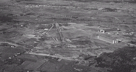
In 1942, while WWII was raging on in Europe and the Pacific, the U.S. Navy began construction of 17 wooden hangars to house K-class airships that would be used for anti-submarine patrol and convoy escort. Two of these hangars were built at Naval Air Station Tilllamook, which was commissioned in December 1942 to serve the Oregon-Washington-California coastal areas.
The construction of the two shelters was very fast, being completed on spring 1943. Stationed at NAS Tillamook was Squadron ZP-33 with a complement of eight K-Class airships. The K-ships were 252 feet long, 80 feet in diameter, and filled with 425,000 cu. ft. of Helium and had a range of 2,000 miles and an ability to stay aloft for three days. With the surrender of Japan on September 2, 1945 and the Japanese submarine threat eliminated, Naval Air Station Tillamook was reduced to functional status and in 1948, decommissioned.
The first use of the facility to launch stratospheric balloons was in 1953. Between January and December that year the site was choosen as one of the launch bases for the balloons taking part of the "Moby Dick" project, an extensive study of the high altitude wind currents performed at staggered altitudes between 50.000 and 100.000 feet by the Air Force over the United States. The balloons remained aloft between 8 hours and 3 days and were able not only to cross the country, but to reach places as far as Canadá.
Once the program ended, the first part of the involvment of the Tillamook navy base with balloons was over.
The balloons make a comeback
A second chapter would be wrote a quarter century later, when several manned balloon projects used the shelter offered by the huge hangars to serve as preparation and launch base of long duration manned projects that pursued different intentions, from performing studies of the pollutants in middle altitudes across america as ocurred with the "Da Vinci Transamerica" project in 1979, to the more ambitious project EarthWinds which in 1990 performed an ill-fated round the world flight attempt.
The third chapter of this history would begin in the middle of the 90's decade. But first we must mention two milestones that occured both in 1992. The first was the establishment in one "Hangar B" of the Tillamook Air Museum, which currently houses about 30 airplanes of different aviation periods, conforming one of the most complete private collections of World war II aircraft throughout the US. The second event, less happy than the first would occur on August 22 when an accidental fire completely destroyed the facilities of "Hangar A".
In 1996 was founded a company called GSSL Inc. with the aim to providing launch, tracking and recovery of stratospheric balloons of small and medium size. The focus of the company were independent users, universities and government agencies, unable to afford the costs and requeriments of larger balloon programs like the one of NASA or the Air Force.
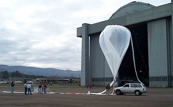
The former navy base becomes the "Tillamook Balloon Facility" being the main operations site for the company. Without dedicated facilities, GSSL Inc. used the structure of Hangar "B" as integration facility for the preparation of the payloads to be flown while the balloons were launched from the airport runway located nearby. GSSL's main users at that time were NASA's Jet Propulsion Laboratory, the National Center for Atmospheric Research (NCAR), the University of Washington and the Department of Defense among others.
In 2004 the company would be renamed to its current denomination: Near Space Corportion (NSC). However, the biggest change for the firm would occur in early 2012.
The Johnson Near Space Center
In February of that year, NSC announced a fundamental improvement in its operational capacities, with the construction of a new launch base near the land occupied by the Tillamook Airport. The project was conducted by the architectural firm LRS of Portland, at a cost of 6.9 million dollars in its first phase, and would become the first US facility dedicated to launch stratospheric balloons oriented exclusively to commercial use, able to handle all operational phases, from the construction of the balloons, to their launch, tracking and recovery.
After more than a year of work, in the spring of 2013, the new facility began operations being formally denominated Johnson Near Space Center during a ceremony held on July 19, 2013. The name seeks to honor Sen. democrat Betsy Johnson, who in the past became involved with different initiatives in the aerospace sector in the state of Oregon and also was instrumental in getting financing for the construction of the new base.
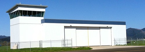
The base have a custom integration hangar of 5.000 square feet of heated space, ideal to prepare all the hardware related to balloon flights. It counts with an avionics laboratory with test benches and atmospheric test chamber, a workshop, individual integration tables and temporary office & meeting space with wireless internet access.
The control tower to support balloon operations counts with aircraft and ground communications and an unobstructed view of the operations field. As the Tillamook airport is an uncontrolled airspace flight station the center has full control of FAA coordination, mission planning & operations oversight. In the 2nd floor of the building lies the Operations Control Center where are located also the ground stations and servers and a briefing room.
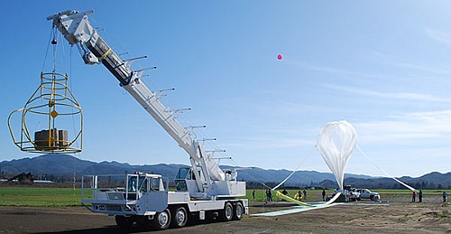
For flight operations the installation counts with a flat paved circular area of 600 meters of diameter, and operates a 25 ton crane used to hold the payloads to be launched or as service truck. It counts also with a self contained (air-conditioned) mobile telemetry & command trailer and additionally it is able to tracking aircraft for airspace de-confliction, telemetry, filming, etc.
In November 2015, as part of the growing scene of the unmanned aerial system (UAS) operations in the United States became operational the Tillamook UAS Test Range as part of the Pan Pacific UAS Test Range Complex, one of the six special FAA designated UAS Test Sites.
On this context, in June 2016 a major upgrade to the Johnson Near Space Center was announced in support of the new collocated Range. The $1.4 million dollar upgrade utilized grants from the State of Oregon, to provide essential infrastructure and key range personnel to further the testing and integration of unmanned aircraft. The upgrades provided a unique instrumented range that encompasses both low and high altitude airspace for the testing of unmanned technologies outside of restricted airspace. The infrastructure included upgrades to the Operations Control Center with new ground stations, secure data servers, local radar/ADS-B coverage, range video & communication systems, SODAR, high altitude sounding system, GPS Simulator, and other specialized test equipment.
The grant also served to support the hiring of a full time Test Range Manager and Range Safety Officer to allow NSC to support more customers.
Nowadays, along with the Johnson Near Space Center, NSC operates two more balloon launch sites in Madras Airport, Oregon and South Point, Hawaii.
Table of balloons launched from Tillamook
| Date | Hour | Flight Duration | Experiment | Payload landing place or cause of the failure |
|---|---|---|---|---|
| 1/20/1953 | 17:07 | 7 h 55 m | MOBY DICK | Payload lost. Last known position of the balloon in flight was 47.7º N - 123.4º W |
| 1/26/1953 | 16:47 | 7 h 10 m | MOBY DICK | Payload lost. Last known position of the balloon in flight was 46.1º N - 119.5º W |
| 2/1/1953 | 16:23 | 58 h | MOBY DICK | Payload lost. Last known position of the balloon in flight was 31.2º N - 103.1º W |
| 2/8/1953 | 16:21 | 30 h 40 m | MOBY DICK | 4 miles S of Anton Chico (Antonhy ?), New Mexico, US |
| 2/13/1953 | 16:58 | 33 h | MOBY DICK | Northwest of Range, Arizona |
| 2/21/1953 | 17:17 | 81 h 40 m | MOBY DICK | 35 miles N of Flagstaff, Arizona |
| 2/23/1953 | 16:32 | 12 h 30 m | MOBY DICK | 12 miles NW of Lena, Mississippi, US |
| 2/26/1953 | 16:23 | 21 h 5 m | MOBY DICK | 22 miles N of Coaldale, Nevada |
| 2/27/1953 | 16:28 | 36 h | MOBY DICK | Payload lost. Last known position of the balloon in flight was 35.0º N - 112.4º W |
| 3/1/1953 | 17:07 | 39 h 25 m | MOBY DICK | In Barnum, Iowa |
| 3/2/1953 | 19:15 | 55 h 50 m | MOBY DICK | In Garden Valley, California |
| 3/4/1953 | 16:36 | 8 h | MOBY DICK | Payload lost. Last known position of the balloon in flight was 43.5º N - 119.7º W |
| 3/5/1953 | 16:55 | 36 h | MOBY DICK | Payload lost. Last known position of the balloon in flight was 39.0º N - 83.0º W |
| 3/6/1953 | 18:50 | 79 h 10 m | MOBY DICK | In Iotta Valley, near the Tennessee river in Tennessee |
| 3/7/1953 | 16:16 | 12 h 40 m | MOBY DICK | Payload lost. Last known position of the balloon in flight was 45.2º N - 120.2º W |
| 3/12/1953 | 16:23 | 7 h 35 m | MOBY DICK | In Grande Round, Washington, US |
| 3/13/1953 | 16:45 | 9 h 50 m | MOBY DICK | Payload lost. Last known position of the balloon in flight was 44.2º N - 120.7º W |
| 3/14/1953 | 16:23 | 8 h 35 m | MOBY DICK | NE of Corner, Sanders County, Montana |
| 3/15/1953 | 16:48 | 12 h 40 m | MOBY DICK | 9 miles NE of Corner, N Dakota |
| 3/18/1953 | 16:52 | 11 h 5 m | MOBY DICK | Payload lost. Last known position of the balloon in flight was 47.2º N - 119.5º W |
| 3/20/1953 | 16:46 | 9 h 10 m | MOBY DICK | 2 miles SE of Farson, Wyoming, US |
| 3/23/1953 | 17:23 | 8 h 35 m | MOBY DICK | 7 miles NW of Enid, Oklahoma |
| 3/26/1953 | --- | COSMIC RADIATION RESEARCH | --- No Data --- | |
| 3/30/1953 | 19:46 | 34 h 10 m | MOBY DICK | Near Glasgow, Montana |
| 4/1/1953 | 16:46 | 8 h 12 m | MOBY DICK | Payload lost. Last known position of the balloon in flight was 43.0º N - 122.6º W |
| 4/2/1953 | 16:28 | 37 h | MOBY DICK | Payload lost. Last known position of the balloon in flight was 33.9º N - 119.5º W |
| 4/9/1953 | 17:01 | 18 h 35 m | MOBY DICK | In Moosonee, Ontario, Canada |
| 4/10/1953 | 16:27 | 10 h 5 m | MOBY DICK | 1 mile S of Kendrick, Wyoming, US |
| 4/13/1953 | 41 h | ANIMAL CAPSULE (UM) | 5 months later in Bend, Oregon, US | |
| 4/14/1953 | 16:41 | 56 h 25 m | MOBY DICK | Payload lost. Last known position of the balloon in flight was 33.8º N - 76.1º W |
| 4/15/1953 | 16:25 | 45 h 5 m | MOBY DICK | Payload lost. Last known position of the balloon in flight was 38.7º N - 86.3º W |
| 4/17/1953 | 17:28 | 8 h 30 m | MOBY DICK | 9 mile SW of Logmount, Colorado |
| 4/24/1953 | 16:16 | 7 h 40 m | MOBY DICK | Payload lost. Last known position of the balloon in flight was 45.8º N - 118.9º W |
| 4/25/1953 | 16:22 | 15 h 40 m | MOBY DICK | Payload lost. Last known position of the balloon in flight was 47.2º N - 122.0º W |
| 4/28/1953 | 18:05 | 35 h 55 m | MOBY DICK | Payload lost. Last known position of the balloon in flight was 49.6º N - 121.7º W |
| 5/3/1953 | 16:46 | 15 h 42 m | MOBY DICK | In Burnstad, N Dakota |
| 5/8/1953 | 16:48 | 67 h 12 m | MOBY DICK | 2 1/2 miles SW of Wenatchee, Washington, US |
| 5/9/1953 | 16:42 | 18 h 48 m | MOBY DICK | In Deep Canyon Ione, Nevada |
| 5/11/1953 | 16:15 | 6 h 48 m | MOBY DICK | 30 miles N of Fairfield, Idaho |
| 5/15/1953 | 16:55 | 14 h 5 m | MOBY DICK | 15 miles W of Pentwater, Michigan, US |
| 5/16/1953 | 16:43 | 9 h 12 m | MOBY DICK | Payload lost. Last known position of the balloon in flight was 42.8º N - 122.4º W |
| 5/17/1953 | 16:25 | 31 h 35 m | MOBY DICK | Payload lost. Last known position of the balloon in flight was 43.4º N - 119.2º W |
| 6/4/1953 | 17:07 | 9 h 30 m | MOBY DICK | In Signal Point, Yellowstone Lake, Wyoming, US |
| 6/8/1953 | 17:05 | 7 h 55 m | MOBY DICK | Payload lost. Last known position of the balloon in flight was 45.8º N - 124.8º W |
| 6/17/1953 | 16:45 | 11 h 50 m | MOBY DICK | 2 miles E of Glasgow, Montana, US |
| 6/18/1953 | 16:36 | 10 h 25 m | MOBY DICK | In the province of Alberta, Canada |
| 6/21/1953 | 19:10 | 27 h 20 m | MOBY DICK | Payload lost. Last known position of the balloon in flight was 49.7º N - 116.5º W |
| 6/23/1953 | 16:55 | 13 h 5 m | MOBY DICK | In Wild Horse, province of Alberta, Canada |
| 6/25/1953 | 16:17 | 25 h 10 m | MOBY DICK | Payload lost. Last known position of the balloon in flight was 48.3º N - 111.9º W |
| 6/28/1953 | 17:02 | 25 h | MOBY DICK | Payload lost. Last known position of the balloon in flight was 49.7º N - 118.5º W |
| 7/3/1953 | 16:17 | 11 h 12 m | MOBY DICK | Payload lost. Last known position of the balloon in flight was 47.3º N - 116.9º W |
| 7/4/1953 | 16:33 | 28 h | MOBY DICK | 15 miles W of Vancouver Island Cape Scott, Canada |
| 7/5/1953 | 16:33 | 6 h 30 m | MOBY DICK | In Bozeman, Montana |
| 7/6/1953 | 16:33 | 13 h 30 m | MOBY DICK | In Maysville, Missouri |
| 7/7/1953 | 16:20 | 17 h 40 m | MOBY DICK | Payload lost. Last known position of the balloon in flight was 49.6º N - 120.9º W |
| 7/16/1953 | 16:48 | 22 h 10 m | MOBY DICK | In Basin, Wyoming |
| 7/17/1953 | 19:23 | 18 h 35 m | MOBY DICK | 3 miles S of Richmond, Ontario Province, Canada |
| 7/19/1953 | 16:47 | 10 h 40 m | MOBY DICK | 50 miles NW of White Sulphur Springs, Montana |
| 7/21/1953 | 16:57 | 6 h 35 m | MOBY DICK | 11 miles E of Gibbon, Oregon, US |
| 7/22/1953 | 16:44 | 11 h 50 m | MOBY DICK | Payload lost. Last known position of the balloon in flight was 48.8º N - 117.5º W |
| 7/24/1953 | 17:11 | 8 h 50 m | MOBY DICK | Payload lost. Last known position of the balloon in flight was 49.2º N - 116.1º W |
| 7/26/1953 | 17:00 | 14 h | MOBY DICK | At 55.3º N - 76.6º W |
| 7/29/1953 | 16:42 | 7 h 50 m | MOBY DICK | Payload lost. Last known position of the balloon in flight was 48.3º N - 120.3º W |
| 7/30/1953 | 16:50 | 7 h 40 m | MOBY DICK | Payload lost. Last known position of the balloon in flight was 48.1º N - 119.9º W |
| 8/1/1953 | 16:55 | 16 h 35 m | MOBY DICK | Payload lost. Last known position of the balloon in flight was 50.6º N - 118.7º W |
| 8/2/1953 | 16:39 | 17 h 20 m | MOBY DICK | In Nova Scotia, Canada |
| 8/10/1953 | 17:23 | 10 h 5 m | MOBY DICK | Payload lost. Last known position of the balloon in flight was 44.0º N - 120.7º W |
| 8/11/1953 | 16:43 | 26 h 17 m | MOBY DICK | Payload lost. Last known position of the balloon in flight was 46.2º N - 113.2º W |
| 8/14/1953 | 17:16 | 91 h 42 m | MOBY DICK | In Manns Harbor, N Carolina |
| 8/30/1953 | 17:14 | 41 h 10 m | MOBY DICK | In Holyoke, Colorado |
| 9/1/1953 | 17:07 | 5 h 55 m | MOBY DICK | Payload lost. Last known position of the balloon in flight was 45.3º N - 122.2º W |
| 9/6/1953 | 17:25 | 25 h 35 m | MOBY DICK | In Freeport, Illinois |
| 9/11/1953 | 17:08 | 14 h 25 m | MOBY DICK | 35 miles W of Meeker, Colorado |
| 9/12/1953 | 17:40 | 76 h 20 m | MOBY DICK | 22 miles W of Hereford, Texas |
| 9/14/1953 | 17:24 | 77 h 5 m | MOBY DICK | Payload lost. Last known position of the balloon in flight was 33.7º N - 81.5º W |
| 9/15/1953 | 17:05 | 8 h 25 m | MOBY DICK | 3 miles SW of Maple Rapids, Michigan |
| 9/16/1953 | 15:55 | 7 h 35 m | MOBY DICK | 2 miles N of Unionville, Missouri, US |
| 9/21/1953 | 17:11 | 6 h 50 m | MOBY DICK | In Sandy Lake, Manitoba Province, Canada |
| 9/24/1953 | 16:54 | 46 h 40 m | MOBY DICK | Payload lost. Last known position of the balloon in flight was 41.2º N - 78.4º W |
| 10/5/1953 | 17:10 | 51 h 50 m | MOBY DICK | Payload lost. Last known position of the balloon in flight was 38.2º N - 113.0º W |
| 10/6/1953 | 19:27 | 81 h 35 m | MOBY DICK | Payload lost. Last known position of the balloon in flight was 38.2º N - 73.5º W |
| 10/7/1953 | 18:37 | 14 h 25 m | MOBY DICK | Payload lost. Last known position of the balloon in flight was 45.6º N - 114.7º W |
| 10/12/1953 | 17:27 | 7 h 5 m | MOBY DICK | Payload lost. Last known position of the balloon in flight was 46.0º N - 123.9º W |
| 10/15/1953 | 17:17 | 27 h 40 m | MOBY DICK | Payload lost. Last known position of the balloon in flight was 49.3º N - 123.3º W |
| 10/23/1953 | 17:40 | 58 h 50 m | MOBY DICK | Payload lost. Last known position of the balloon in flight was 35.8º N - 124.5º W |
| 10/25/1953 | 17:17 | 25 h 40 m | MOBY DICK | 10 miles S of McEwen, Oregon, US |
| 10/26/1953 | 17:16 | 14 h 45 m | MOBY DICK | In Lame Deer, Montana |
| 11/2/1953 | 17:55 | 26 h 35 m | MOBY DICK | 18 miles NW of Pipestone, Minnesota, US |
| 11/13/1953 | 17:22 | 15 h 35 m | MOBY DICK | Payload lost. Last known position of the balloon in flight was 49.2º N - 117.5º W |
| 12/9/1953 | 23:40 | 20 h 50 m | MOBY DICK | Payload lost. Last known position of the balloon in flight was 41.7º N - 123.6º W |
| 12/17/1953 | 17:53 | 15 h 5 m | MOBY DICK | In Alberta Province, Canada |
| 11/28/1958 | 14:58 local | --- | NUCLEAR EMULSIONS | --- No Data --- |
| 9/26/1979 | 8:16 pdt | 135 h | DA VINCI TRANSAMERICA (Birch - Engelmann - Hyde - Simons) | Near Lima, Ohio, US |
| 9/8/1990 | 31 h | EARTHWINDS (Dzhanibehov - Lachenmeier - Moses - Newman) | In Omak, Washington, US | |
| 8/9/2001 | --- | KITTY HAWK 3 | Tillamook Airport, Oregon, US | |
| 2/28/2002 | 4 h 45 m | DRIFTSONDE TEST | --- No Data --- | |
| 5/15/2002 | 4 h 13 m | SPRITE | --- No Data --- | |
| 6/21/2002 | 15:35 utc | 15 h 30 m | GAINS (Global Atmosphere-ocean IN-situ System) - Prototype III | South of The Dalles, Oregon, US |
| 9/19/2002 | 10:15 pdt | 3 h 13 m | ARES (Aerial Regional-scale Environmental Survey of Mars) | In the strip of the Tillamook Airport, Oregon, US |
| 11/14/2002 | 5 h | DRIFTSONDE TEST | --- No Data --- | |
| 2/10/2003 | 22 h 30 m | DRIFTSONDE TEST | --- No Data --- | |
| 8/19/2003 | 11 h 30 m | DRIFTSONDE TEST | --- No Data --- | |
| 9/2/2003 | 63 h 30 m | DRIFTSONDE TEST | --- No Data --- | |
| 2/15/2013 | 11:24 pst | 3 h 32 m | ADS-B (Automatic Dependent Surveillance - Broadcast) | --- No Data --- |
| 7/19/2013 | --- | HASS (High Altitude Shuttle System) | --- No Data --- | |
| 9/26/2013 | --- | SATELLITE COMMUNICATION SYSTEM TEST | --- No Data --- | |
| 12/5/2013 | F 1 h 20 m | ADS-B (Automatic Dependent Surveillance - Broadcast) | --- No Data --- | |
| 6/6/2014 | 52 m | GPHAR (Guided Parafoil High Altitude Research) | Near Beaver, Oregon, US | |
| 6/21/2015 | --- | SMALL PAYLOAD RETURN CAPSULE | --- No Data --- | |
| 9/26/2016 | --- | HASS (High Altitude Shuttle System) | --- No Data --- | |
| 10/3/2016 | --- | HASS (High Altitude Shuttle System) | --- No Data --- | |
| 5/19/2017 | --- | 1090 MHZ ADS-B TEST FLIGHT | --- No Data --- | |
| 9/2/2017 | --- | HASS (High Altitude Shuttle System) | --- No Data --- | |
| 10/15/2018 | --- | ANIMAL TRACKER GROUND STATION - TAG TESTING | --- No Data --- | |
| 11/18/2018 | --- | SATELLITE-BASED ADS-B | --- No Data --- | |
| 8/26/2020 | 16:00 utc | 2 h 15 m | PAYLOAD UNKNOWN | 3 miles NE of Jordan Creek, Oregon, US |
| 8/31/2022 | 19:35 utc | 8 h | PAYLOAD UNKNOWN | In the Columbia River, near Scappoose, Oregon, US |
| 5/12/2023 | 13:10 utc | 1 h 40 m | PAYLOAD UNKNOWN | --- No Data --- |
| 9/6/2023 | 14:10 utc | 5 h | PAYLOAD UNKNOWN | NW of Hillsboro, Oregon, US |
If you consider this website interesting or useful, you can help me to keep it up and running with a small donation to cover the operational costs. Just the equivalent of the price of a cup of coffee helps a lot.
